
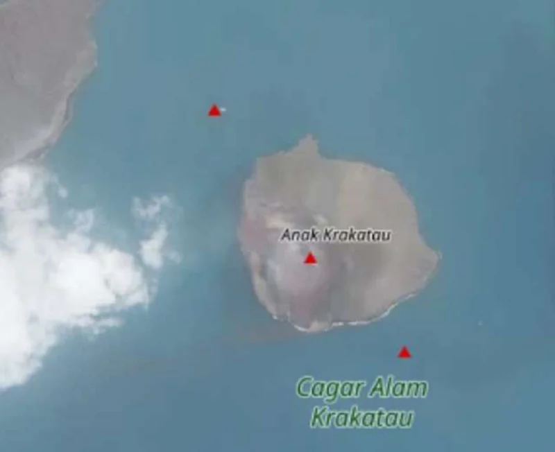
The geological landscape of the Sunda Strait underwent a dramatic transformation this week as two new islands emerged in the vicinity of the Anak Krakatau volcano. Reported on Tuesday, September 22, 2026, the emergence of these landmasses has captured the attention of both the scientific community and local maritime authorities, prompting a rigorous investigation by the Indonesian Geological Agency. The islands, situated in the northwest and southeast sectors of the volcanic complex, are believed to be direct manifestations of the persistent eruptive cycle that has gripped the region for the past several months.
A New Geological Phenomenon in the Sunda Strait
The discovery was not initially detected by automated sensors but was brought to light through the observant eyes of local sailors and volunteer monitors navigating the waters of the Sunda Strait. These reports were subsequently corroborated by satellite imagery, specifically from the Sentinel earth observation mission, which confirmed the presence of distinct landforms rising above the sea surface.
According to Lana Saria, Head of the Geological Agency, the spatial distribution of these islands is highly significant. The northwestern island is located approximately 760 meters from the main body of Anak Krakatau, while the southeastern island is situated about 495 meters away. When mapped, these points, in conjunction with the main crater of Anak Krakatau, form a precise linear orientation trending northwest to southeast.
"The alignment suggests a structural connection to the magmatic plumbing system of the volcano," Saria noted in a formal statement released on Thursday, September 24, 2026. "However, while we interpret these as byproducts of the ongoing eruptive phase, we are currently withholding judgment on whether these represent new, independent eruptive vents or are simply accumulations of tephra and volcanic debris pushed upward by subterranean pressure. Comprehensive field analysis and bathymetric surveys are currently being prioritized to determine the exact composition and stability of these new landforms."
Chronology of the 2026 Eruptive Cycle
To understand the sudden appearance of these islands, one must examine the recent history of the Anak Krakatau volcanic complex. After a period of relative dormancy or low-level activity that concluded in December 2023, the volcano entered a new phase of heightened restlessness in the summer of 2026.
The current escalation began on July 2, 2026. Within days of the initial tremor, the Geological Agency raised the alert status of the volcano to Level III (Siaga), indicating a significant increase in seismic activity and the potential for hazardous eruptions. Throughout July and August, the volcano exhibited a series of Strombolian-type eruptions. These events, characterized by rhythmic bursts of incandescent lava, rock fragments, and dense ash plumes, continued unabated until September 3, 2026.
The period between September 3 and the discovery of the islands on September 22 was marked by a transition in the volcano’s behavior, characterized by less visible surface activity but continued subsurface displacement. The appearance of the islands is now viewed as the physical culmination of these three months of internal pressure and material ejection.
Historical Context and Volcanic Vulnerability
Anak Krakatau is no stranger to dramatic morphological changes. As the "child" of the legendary 1883 Krakatoa eruption—one of the most catastrophic volcanic events in recorded history—Anak Krakatau has been in a near-constant state of growth since its emergence in 1927.
The volcano’s history is defined by its volatile nature and its capacity for rapid structural collapse. The most notable recent event occurred in December 2018, when a significant flank collapse triggered a tsunami that devastated coastal regions in Banten and Lampung. That event resulted in the loss of nearly two-thirds of the volcano’s height and volume, reshaping the island significantly.
Because of this history, the Geological Agency maintains a high-frequency monitoring network. The volcano is currently tracked by two primary observation posts: PGA Kalianda in Lampung and Pasauran in Banten. These posts utilize seismometers, GPS ground deformation monitors, and visual observation to track the volcano’s "health." The emergence of new islands adds a layer of complexity to these monitoring efforts, as the potential for local, small-scale tsunami events remains a constant concern for authorities if the newly formed landmasses were to suffer a sudden underwater landslide.
Scientific Analysis and Implications
The scientific community is currently evaluating the stability of the two new islands. Geological analysts point out that volcanic islands formed during active eruptive phases are often composed of loose, unconsolidated pyroclastic material. Consequently, they are highly susceptible to rapid erosion by wave action and currents in the Sunda Strait.
"We are treating these islands as unstable geological features," said a senior volcanologist associated with the monitoring team. "Until we can confirm the presence of solidified lava or a stable volcanic plug, there is a risk that these islands could be short-lived. Furthermore, the proximity of these features to the main crater suggests that the volcanic conduit may be widening or shifting its stress distribution. This is a critical data point for our risk assessment models."
The implication for maritime traffic is also a primary concern. The Indonesian Ministry of Transportation, in coordination with the Geological Agency, has issued a notice to mariners (NOTAM) to maintain a safe distance from the volcanic complex. The sudden appearance of shallow-water obstacles poses a navigation hazard, particularly for smaller fishing vessels and tourist boats that frequent the Sunda Strait.
Official Response and Public Safety Protocols
In response to the developments, the Indonesian government has reinforced its safety protocols. Level III (Siaga) remains in effect, and the following mandates are strictly enforced:
- Exclusion Zones: A strict radius of four to five kilometers from the active crater remains closed to all human activity, including tourism, fishing, and unauthorized scientific research.
- Enhanced Monitoring: The Geological Agency has deployed additional hydro-acoustic sensors to monitor underwater tremors that may precede further structural changes or submarine eruptions.
- Community Preparedness: Local governments in Lampung and Banten have been instructed to refresh their tsunami evacuation drills and ensure that early warning systems are fully operational. While the current activity does not immediately signal a major tsunami threat, the memory of the 2018 disaster ensures that emergency services remain on high alert.
Looking Toward the Future
The emergence of these two islands is a stark reminder of the dynamic and unpredictable nature of the Sunda Strait. As the Geological Agency continues to collect data, the global scientific community is watching closely. The phenomenon provides a rare opportunity to observe the birth of volcanic landforms in real-time, offering insights into the magmatic processes that have shaped this region for centuries.
For the residents of the nearby coastal provinces, the situation is a call for vigilance. The Geological Agency has promised to provide daily updates as new data from satellite imagery and field observations become available. The public is advised to rely solely on official communication channels and to disregard speculative information circulating on social media platforms.
As of late September 2026, the situation remains fluid. The eruptive intensity may have paused in early September, but the birth of these two islands indicates that the underlying volcanic engine of Anak Krakatau remains deeply active. Whether these islands will remain as permanent features of the Indonesian archipelago or succumb to the relentless forces of the sea remains a question that only time—and the unpredictable tremors of the earth—will answer.
