
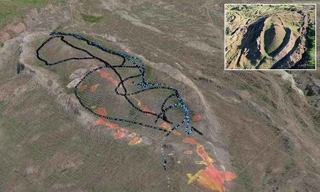
The long-standing historical and theological debate regarding the final resting place of Noah’s Ark has entered a new phase following recent geological investigations in eastern Turkey. A team of international researchers, collaborating under the banner of Noah’s Ark Scans and supported by academic institutions, has released data from sophisticated subsurface scanning near Mount Ararat, suggesting that a distinct, ship-shaped geological formation could be the remains of the vessel described in ancient religious texts. This development has reignited interest among archaeologists, theologians, and the public, prompting a formal scientific inquiry into a site that has been a subject of speculation for decades.
Geographical Context and the Durupinar Site
The site in question is known as the Durupinar formation, located in the Doğubayazıt district of Ağrı Province, roughly 18 miles south of the Greater Mount Ararat summit. For decades, the site has been characterized by a natural depression that bears a striking resemblance to the hull of a large vessel, measuring approximately 157 meters in length. While previous generations of explorers often dismissed the formation as a natural phenomenon—specifically a syncline or a landslide feature—the latest mission claims that ground-penetrating radar (GPR) and electrical resistivity tomography have uncovered internal structures that do not align with natural geological formations.
Andrew Jones, a representative of the Noah’s Ark Scans organization, stated during a recent media briefing that the data suggests the presence of artificial, man-made components buried deep within the sedimentary layers. "We are looking at what appears to be a ship that has been subject to immense geological pressure and environmental decay over thousands of years," Jones noted. The research team asserts that the scans indicate the presence of rigid, geometric boundaries that distinguish the formation from the surrounding terrain, which is primarily composed of volcanic rock and alluvial soil.
Chronology of the Investigation
The quest to identify the resting place of the Ark has a history spanning over a century, but modern, technology-driven efforts began in earnest in the late 20th century. The Durupinar site was first brought to international attention in 1959 by Captain Ilhan Durupinar, a Turkish army officer who identified the shape while reviewing aerial photography taken by NATO.
The timeline of the current project began in 2023, when a formal coalition was formed between the Sivas Cumhuriyet University in Turkey and California-based Noah’s Ark Scans. Following months of negotiations with the Turkish Ministry of Culture and Tourism, the team received authorization to conduct a comprehensive geological and archaeological survey. In September 2026, the team commenced a multi-phase operation:
- September 2026: Initial soil sampling and electrical resistivity tomography (ERT) scans were conducted to map the density variations beneath the surface.
- October 2026: Preliminary analysis of the GPR data revealed a series of rectangular voids and dense, metallic-like readings at depths of up to 18 meters.
- November 2026: The research team, led by archaeologist Cenker Atila, began the process of cross-referencing the structural findings with historical flood accounts and regional tectonic activity.
The mission is characterized by a shift toward evidence-based methodology, moving away from purely speculative expeditions toward rigorous academic peer review.
Scientific Methodology and Technical Findings
The core of the recent announcement rests on the technical data provided by the Noah’s Ark Scans team. Unlike earlier expeditions that relied on visual observation or amateur excavations, the 2026 study utilized high-frequency electromagnetic sensors capable of penetrating the dense soil layers of the Ağrı Province.
According to Dr. Cenker Atila, the lead archaeologist from Sivas Cumhuriyet University, the team identified anomalies that suggest a "stacked" construction method. "The subterranean patterns we are seeing are consistent with a deliberate, organized assembly of materials," Dr. Atila explained. He noted that the geological composition of the site is distinct from the surrounding mountain slope, which is characterized by chaotic sediment deposits. The site, by contrast, shows a degree of symmetry that is rarely found in natural landslides.
However, the scientific community remains cautious. Geologists point out that the region is prone to tectonic shifts and that "ship-shaped" formations can often be the result of "mud volcanoes" or complex rock strata layering. The challenge for the research team will be to present material evidence—such as fossilized wood samples, bitumen remains, or metal artifacts—that can be carbon-dated to a timeframe consistent with historical or mythological accounts of a great deluge.
Official Responses and Academic Skepticism
The Turkish government has maintained a balanced stance, providing the necessary permits for scientific exploration while avoiding official endorsement of the "Noah’s Ark" hypothesis. For the Turkish Ministry of Culture and Tourism, the project represents an opportunity to clarify the archaeological landscape of the Ağrı region, which has significant tourism potential regardless of the final verdict on the Ark.
Conversely, the global archaeological establishment has voiced skepticism. Mainstream researchers emphasize that the geological history of the Mount Ararat region is characterized by extreme volcanic activity, which often creates bizarre rock formations that can deceive the untrained eye. Dr. David Miller, a historical geologist not affiliated with the study, noted, "While the GPR data is certainly interesting, the burden of proof for such a monumental claim requires peer-reviewed analysis of physical samples. We have seen many ‘potential’ sites before, and most have proven to be natural features when subjected to rigorous laboratory testing."
The researchers behind the current project acknowledge this skepticism and have pledged to release their full dataset for independent analysis in the coming year. They argue that the sheer scale of the 157-meter formation is too consistent with historical measurements of the Ark to be dismissed as a mere geological coincidence.
Implications and Future Outlook
The implications of confirming the existence of the Ark would be profound, transcending the boundaries of archaeology and entering the realms of cultural heritage and theology. For millions of people, the discovery would serve as empirical validation of religious narratives that have shaped civilizations for millennia. For the scientific community, it would provide a unique case study in ancient maritime engineering and the potential for preserving organic material under specific, high-pressure geological conditions.
However, the path forward is complex. The site is located in a high-altitude, seismically active area, making excavation difficult and potentially hazardous. Furthermore, the region is subject to strict environmental regulations that limit the scope of invasive digging. The team intends to continue their work through non-invasive scanning for the remainder of the 2026-2027 season, with plans for limited, precision-based core drilling in the following year, provided that further funding and administrative approvals are secured.
The project also highlights the growing intersection of private exploration and institutional archaeology. By combining the financial and technical resources of private organizations like Noah’s Ark Scans with the academic oversight of universities, these expeditions aim to provide a more transparent and credible framework for investigating historical mysteries.
As the scientific world waits for the final results of the 2026 data analysis, the Durupinar site remains a focal point of intense discussion. Whether the formation is eventually categorized as a revolutionary archaeological breakthrough or an elaborate natural curiosity, the dedication to uncovering the truth behind this ancient legend remains a testament to the enduring human fascination with our collective past. The upcoming report from the Sivas Cumhuriyet University is expected to provide the most detailed map of the structure to date, potentially offering a definitive answer to a question that has persisted for generations.
The debate serves as a reminder that the search for historical truth is a slow, iterative process, requiring the patience of researchers and the scrutiny of the global scientific community. As of now, the data from the Arafat region remains a compelling piece of a much larger puzzle, one that continues to draw researchers to the rugged, snow-capped landscapes of eastern Turkey.
