
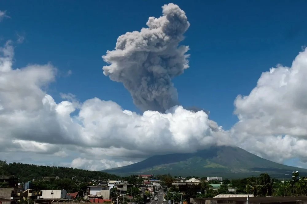
The Philippine Institute of Volcanology and Seismology (PHIVOLCS) has officially elevated the alert status of Mount Mayon to Level 3, signaling an increased risk of hazardous eruptions following a significant magmatic event on Friday, October 30, 2026. The volcano, renowned for its near-perfect symmetrical cone, unleashed a massive plume of ash, rising approximately 3,000 meters into the atmosphere, marking the start of what experts describe as a volatile new phase in its geological activity.
The eruption, which lasted for nearly six minutes, was characterized by seismologists as a "moderately explosive" event. While the immediate aftermath has not yielded reports of casualties or widespread infrastructure damage, the transition to a Level 3 alert serves as a stern warning to the millions residing in the Albay province. Authorities have mandated the immediate evacuation of all residents located within a six-kilometer Permanent Danger Zone (PDZ) surrounding the crater, citing the imminent threats posed by pyroclastic density currents (PDC), lava flows, and rockfalls.
A Geologically Unstable Landmark
Mount Mayon is arguably the most iconic and dangerous volcano in the Philippines. Situated in the Bicol Region on the island of Luzon, it stands at an elevation of 2,463 meters. Its history is marked by frequent eruptions, with over 50 recorded instances in the last 400 years. The volcano’s reputation is built on its beauty—often compared to Mount Fuji in Japan—but also on its lethal capacity to produce rapid, destructive flows of gas and volcanic matter.
The 2026 event follows a period of localized seismic unrest that had been monitored by PHIVOLCS for several weeks. However, the sudden intensity of the Friday eruption caught many by surprise, forcing local government units (LGUs) to mobilize disaster risk reduction protocols almost instantaneously. The ash plume, which drifted in a southwesterly direction, has raised concerns regarding respiratory health for nearby communities and the potential disruption of local agriculture, a primary economic driver in the Bicol region.
Chronology of the 2026 Escalation
The transition to Level 3 did not occur in a vacuum. For the preceding month, PHIVOLCS sensors had detected a subtle but steady increase in sulfur dioxide (SO2) emissions, a primary indicator of magma rising through the volcano’s internal plumbing system.
On the morning of October 30, 2026, at approximately 10:45 AM local time, seismic instruments recorded a series of volcanic earthquakes, followed shortly by the explosive discharge of ash. By 11:00 AM, the ash column had reached the 3,000-meter mark, obscuring the summit. By 12:30 PM, the PHIVOLCS observatory released an emergency bulletin, formally raising the alert level from 2 to 3.
This escalation implies that the volcano is experiencing a magmatic eruption. Unlike phreatic eruptions—which are driven by steam and water—magmatic eruptions involve the direct movement of molten rock from the Earth’s crust, posing a significantly higher risk of sustained activity and long-range damage.
Understanding the Hazards of Level 3
Under the PHIVOLCS alert system, Level 3 denotes that the volcano is undergoing relatively high unrest and that magma is at the crater. The primary concerns during this phase include:
- Pyroclastic Density Currents (PDCs): Often referred to as "nuées ardentes," these are fast-moving avalanches of hot gas, ash, and volcanic rock. They can travel at speeds exceeding 100 kilometers per hour and are lethal to anything in their path.
- Lava Flows: Persistent effusions of lava can travel down the slopes, destroying farmland and obstructing roadways.
- Rockfalls: As the volcanic dome becomes unstable, gravitational collapses of rock are frequent, posing a constant threat to those near the base.
- Ashfall: Fine volcanic ash can cause respiratory distress, contaminate water supplies, and lead to the collapse of roofs under the weight of accumulated debris.
The National Disaster Risk Reduction and Management Council (NDRRMC) has issued directives to local officials to ensure that the six-kilometer radius is strictly enforced. Aerial navigation has also been restricted, with the Civil Aviation Authority of the Philippines (CAAP) advising pilots to avoid flying near the summit to prevent damage from airborne ash and volcanic gases, which can cause engine failure.
Socio-Economic Implications for Albay
The Albay province relies heavily on tourism, with Mount Mayon serving as the centerpiece of its branding. The immediate closure of trekking trails and the evacuation of surrounding villages will have an undeniable impact on the local economy. However, the provincial government has prioritized human safety, citing the catastrophic eruption of 2018, which displaced nearly 90,000 people and caused significant damage to local crops.
Economists note that the Bicol region is highly susceptible to climate-related and geological shocks. The sudden shift in agricultural output due to ash coverage can lead to localized inflation of basic goods. Furthermore, the cost of emergency sheltering—housing thousands of displaced residents—places a significant strain on the provincial budget, necessitating support from the national government in Manila.
Scientific Analysis and Expert Perspective
Volcanologists monitoring Mayon emphasize that while the current activity is contained, the unpredictable nature of the volcano requires constant vigilance. Data from the last 48 hours indicates that the summit’s sulfur dioxide flux has increased by nearly 40% compared to last week’s baseline. This suggests a continuous supply of magma is being pushed toward the surface.
"The current state of Mayon suggests we are in for a prolonged period of activity," said a senior researcher at the Bicol Volcanological Observatory. "While we cannot predict the exact timing of a larger eruption, the current indicators show that the volcano is primed. We are looking at the possibility of persistent activity spanning days, or potentially weeks, as the volcanic system seeks a new state of equilibrium."
The international community, including groups like the United States Geological Survey (USGS), is coordinating with Philippine authorities to share satellite imagery and thermal mapping data. This collaboration is vital for tracking the growth of lava lobes and the trajectory of potential PDCs, which are often difficult to track from ground-level observatories during periods of heavy cloud cover.
Official Response and Public Safety Measures
Presidential spokespersons have assured the public that the national government is prepared to provide relief goods, medical supplies, and temporary housing for those evacuated from the danger zone. In a press statement issued late Friday, the government urged citizens to refrain from spreading unverified information on social media, which often exacerbates public anxiety.
"The safety of our citizens in Albay is the paramount concern," the statement read. "We ask the public to remain calm, stay informed through official PHIVOLCS channels, and strictly adhere to the guidelines provided by local disaster response units."
Evacuation centers are being retrofitted with health protocols to prevent the spread of diseases, a lesson learned during previous disaster management efforts in the Philippines. Schools within the radius have been suspended indefinitely, and the Department of Social Welfare and Development (DSWD) has begun prepositioning food packs to ensure sustained support for the affected families.
The Path Forward
As of late Friday evening, the situation remains fluid. While there has been a minor decrease in the frequency of tremors, the presence of an active magma dome remains a critical concern. Authorities are maintaining the Level 3 status, indicating that the threat of a hazardous, explosive eruption remains imminent.
For the people of Albay, the sight of the glowing summit is a familiar but unwelcome reminder of the volatile landscape they call home. The resilience of the Bicolano people will once again be tested as they prepare for the possibility of a prolonged volcanic crisis. PHIVOLCS continues to maintain a 24-hour watch, providing hourly updates to local governments to facilitate real-time decision-making.
As the sun sets on the town of Legazpi, the glow from Mount Mayon acts as a stark, silent warning. The scientific community, the government, and the citizens are now locked in a waiting game, hoping that the volcano’s current display of force does not escalate into a major humanitarian emergency. The world looks on, as one of nature’s most magnificent and formidable structures reminds humanity of the raw, unpredictable power beneath the Earth’s surface.
