
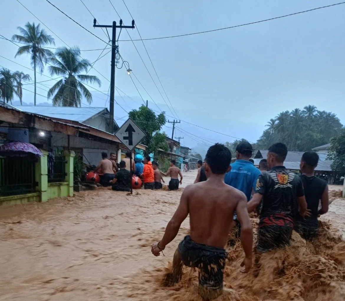
Hutanabolon, Tapanuli Tengah, North Sumatra – A devastating flash flood, triggered by relentless high-intensity rainfall, swept through the Hutanabolon region of Tapanuli Tengah, North Sumatra, on Saturday, July 18, 2026. The deluge, which caused rivers to overflow their banks, submerged residential areas, reaching depths of up to an adult’s waist, before gradually receding on Sunday morning, July 19, 2026. The swift-moving waters left a trail of destruction, prompting immediate evacuation efforts and highlighting the persistent vulnerability of communities to extreme weather events.
The catastrophic event unfolded after prolonged and unusually heavy rainfall battered the Tapanuli Tengah regency throughout Saturday. The downpour, described by local residents as incessant, caused several major rivers in the area to swell rapidly. By late Saturday afternoon, the sheer volume of water overwhelmed the natural riverine systems, leading to a sudden and powerful overflow that cascaded into low-lying settlements. The speed and force of the flash flood caught many residents off guard, transforming streets into torrents and quickly inundating homes. Emergency services were immediately mobilized as the scale of the disaster became apparent, with local authorities initiating rapid response protocols to mitigate further loss and ensure public safety.
Chronology of the Disaster and Immediate Response
The sequence of events began with the onset of heavy precipitation across the Tapanuli Tengah region on the morning of Saturday, July 18, 2026. Meteorological data, later analyzed by the local branch of the Meteorology, Climatology, and Geophysics Agency (BMKG), indicated rainfall intensities significantly exceeding typical seasonal averages for the area, likely contributing to the rapid saturation of the ground and the subsequent surge in river levels. As the rain continued unabated into the afternoon, reports of rising water levels in various river systems began to surface. By approximately 5:00 PM local time, residents in the lowest-lying areas of Hutanabolon reported initial signs of flooding. Within hours, the situation escalated dramatically, with floodwaters surging to waist-high levels in many residential zones, particularly along the riverbanks.
The Regional Disaster Management Agency (BPBD) of Tapanuli Tengah Regency, in conjunction with combined forces including local police, military personnel, and community volunteers, initiated emergency response operations late Saturday evening. Their immediate priority was the evacuation of residents trapped or at risk in their homes. One of the most severely impacted communities was Kelurahan Sipange, where 145 individuals were swiftly moved to the safety of the HKBP Sipange Church, which was designated as a temporary evacuation center. This coordinated effort undoubtedly prevented potential casualties and provided a secure haven for those displaced by the sudden inundation. Throughout the night, teams worked tirelessly, navigating challenging conditions to reach affected areas and transport vulnerable populations, including children, the elderly, and those with disabilities, to higher ground.
By Sunday morning, July 19, 2026, a sense of cautious relief emerged as the floodwaters began to recede. While the immediate threat diminished, the full extent of the damage became visible, revealing houses filled with mud and debris, damaged infrastructure, and the widespread disruption to daily life. BPBD personnel remained on site, transitioning from immediate rescue to damage assessment and continued support for the displaced population.
Scope of Impact and Damage Assessment
The flash flood’s reach was extensive, impacting a total of seven sub-districts (kelurahan) spread across four distinct districts (kecamatan) within Tapanuli Tengah. These affected districts included Tukka, Badiri, Pinangsori, and Sarudik, indicating a broad geographical spread of the disaster rather than an isolated incident. The sheer number of affected administrative units underscores the widespread nature of the heavy rainfall and the vulnerability of various communities along the region’s river systems.
While the exact monetary value of the damage is still under assessment, initial reports suggest significant losses to property and local infrastructure. Many homes suffered structural damage, with foundations weakened and interiors ruined by mud and water. Essential household items, furniture, and personal belongings were either swept away or rendered unusable. Local roads and bridges, crucial for connectivity and commerce, also bore the brunt of the flood’s force, with some sections potentially damaged or made impassable, hindering immediate recovery efforts and the delivery of aid to more remote areas. The long-term impact on livelihoods, particularly for those engaged in agriculture or small businesses, is expected to be substantial, requiring comprehensive recovery programs.
The displacement of 145 individuals from Kelurahan Sipange to the HKBP Sipange Church highlights the immediate humanitarian crisis. These individuals, representing numerous households, faced the trauma of leaving their homes and the uncertainty of their return. The establishment of a public kitchen at the evacuation center was a critical step in addressing their immediate needs for food and clean water, preventing potential health crises in the aftermath of the disaster. Beyond the physical damage, the psychological toll on affected residents, particularly those who have experienced previous floods, cannot be underestimated. The loss of personal effects, the disruption of daily routines, and the constant threat of future events contribute to significant stress and anxiety within the community.
Government and Agency Response: Coordination and Continued Vigilance
Abdul Muhari, Head of the National Disaster Management Agency (BNPB) Data, Information, and Communication Center, provided an official statement confirming the details of the flood and the ongoing response efforts. His announcement on Sunday, July 19, 2026, underscored the national agency’s oversight and support for local initiatives. "The affected areas include seven sub-districts across four districts: Tukka, Badiri, Pinangsori, and Sarudik," Muhari stated, emphasizing the breadth of the impact. He further detailed the immediate actions taken by the BPBD Kabupaten Tapanuli Tengah and combined teams, including the successful evacuation of residents and the establishment of public kitchens. This coordinated approach between national and regional disaster management bodies is crucial in ensuring an effective and swift response to emergencies of this scale.
BNPB’s role extends beyond immediate relief; it also involves proactive warnings and fostering community resilience. Muhari reiterated BNPB’s call for increased public preparedness, particularly given the dynamic weather patterns. Despite being in what is typically considered the dry season, the region is experiencing anomalous weather. "Until now, BPBD Kabupaten Tapanuli Tengah personnel remain on standby at the location and are documenting flood damages," he added, indicating the transition from emergency response to comprehensive data collection for future recovery and mitigation planning. This data will be instrumental in informing aid distribution, reconstruction efforts, and developing more robust disaster preparedness strategies for the future.
The emphasis on continued vigilance is particularly pertinent given the meteorological forecasts. Based on BMKG’s predictions, North Sumatra is expected to experience light to moderate rainfall in the coming days. This forecast, while not predicting another immediate major flood, highlights the ongoing risk and the need for residents and authorities to remain alert.
Underlying Causes and Environmental Factors
The flash flood in Hutanabolon is a complex interplay of meteorological phenomena and environmental vulnerabilities. BMKG attributes the continued rainfall in North Sumatra, even during the typical dry season, to several key factors. Abdul Muhari, quoting BMKG analysis, explained, "Rainfall occurs due to the continued activity of atmospheric waves, the presence of wind shear in the Indian Ocean west of Sumatra, and warm sea surface temperatures supporting the formation of rain clouds."
- Atmospheric Waves: These are disturbances in the atmosphere that can lead to the formation of rain-bearing clouds. Their increased activity indicates a deviation from typical weather patterns.
- Wind Shear (Belokan Angin): This refers to a significant change in wind speed or direction over a short distance. In the Indian Ocean west of Sumatra, wind shear can create conditions conducive to the development of convective clouds, which are responsible for heavy downpours.
- Warm Sea Surface Temperatures: Warmer ocean waters provide more moisture to the atmosphere through evaporation, fueling the formation of intense rain clouds. This phenomenon is often linked to broader climate patterns and can exacerbate the intensity of rainfall events.
Beyond these immediate meteorological causes, the vulnerability of regions like Tapanuli Tengah to flash floods can also be influenced by underlying environmental factors. Deforestation, particularly in upstream areas, can significantly reduce the land’s capacity to absorb rainwater. When forests are cleared, soil erosion increases, and rainwater runs off rapidly into rivers, contributing to faster and more intense flooding downstream. While the immediate cause of this particular flood was intense rainfall, the broader landscape management practices in the region could play a role in exacerbating the impact of such events. The topography of Tapanuli Tengah, characterized by hilly terrain and numerous river systems flowing towards the coast, naturally makes it susceptible to rapid runoff and flash floods, especially during periods of extreme precipitation.
Broader Impact and Implications
The Hutanabolon flood carries significant broader implications, extending beyond the immediate physical damage and displacement.
- Socio-Economic Impact: The disruption to daily life, loss of homes, and potential damage to agricultural land or small businesses will have a lasting socio-economic impact on the affected communities. Recovery will require substantial resources, including financial aid, housing reconstruction, and support for restoring livelihoods. The psychological trauma experienced by residents, especially children, can also have long-term effects on community well-being and resilience.
- Public Health Concerns: Post-flood environments pose significant public health risks. Contaminated water sources, stagnant pools of water, and damaged sanitation systems can lead to outbreaks of waterborne diseases such as cholera, typhoid, and dengue fever. The provision of clean water, sanitation facilities, and health monitoring will be critical in the coming weeks and months.
- Infrastructure Resilience: The damage to roads, bridges, and other public infrastructure highlights the need for more resilient construction standards, particularly in areas prone to natural disasters. Investing in flood-resistant infrastructure and improving drainage systems can mitigate the impact of future events.
- Climate Change Context: While specific attribution to climate change requires detailed scientific study, the increasing frequency and intensity of extreme weather events globally, including anomalous rainfall patterns, are consistent with climate change projections. This incident serves as a stark reminder for Indonesia, a country highly vulnerable to climate impacts, to bolster its climate adaptation and disaster risk reduction strategies.
- Disaster Preparedness and Early Warning Systems: The swift evacuation efforts demonstrate effective local BPBD response. However, the suddenness of the flash flood also underscores the need for robust early warning systems that can provide communities with sufficient lead time to prepare and evacuate. This includes improved meteorological forecasting capabilities, efficient communication channels to local communities, and well-rehearsed evacuation drills.
Community Resilience and Future Preparedness
The resilience demonstrated by the people of Hutanabolon and the rapid response of local authorities and volunteers are commendable. The quick establishment of evacuation centers and public kitchens highlights the capacity for collective action in times of crisis. However, the recurring nature of such events in various parts of Indonesia necessitates a continuous focus on long-term preparedness. This includes:
- Education and Awareness: Ongoing campaigns to educate communities about flood risks, evacuation routes, and emergency procedures.
- Infrastructure Investment: Strategic investments in flood control infrastructure, such as improved drainage, riverbank reinforcement, and sustainable urban planning.
- Environmental Management: Reforestation programs, particularly in upstream watersheds, and stricter controls on land-use changes to enhance natural water absorption and reduce runoff.
- Technological Integration: Utilizing advanced meteorological forecasting tools and integrating them with local early warning systems, potentially leveraging mobile technology for rapid dissemination of alerts.
- Multi-stakeholder Collaboration: Strengthening partnerships between government agencies, NGOs, academic institutions, and local communities to develop holistic disaster risk reduction strategies.
As the community of Hutanabolon begins the arduous process of recovery, the immediate focus remains on providing humanitarian aid, assessing the full extent of the damage, and planning for reconstruction. The event serves as a potent reminder of the ever-present threat of natural disasters and the imperative for comprehensive, proactive measures to safeguard lives and livelihoods in vulnerable regions like Tapanuli Tengah. The lessons learned from this flood will undoubtedly inform future policies and strategies aimed at building a more resilient Indonesia in the face of a changing climate.
