
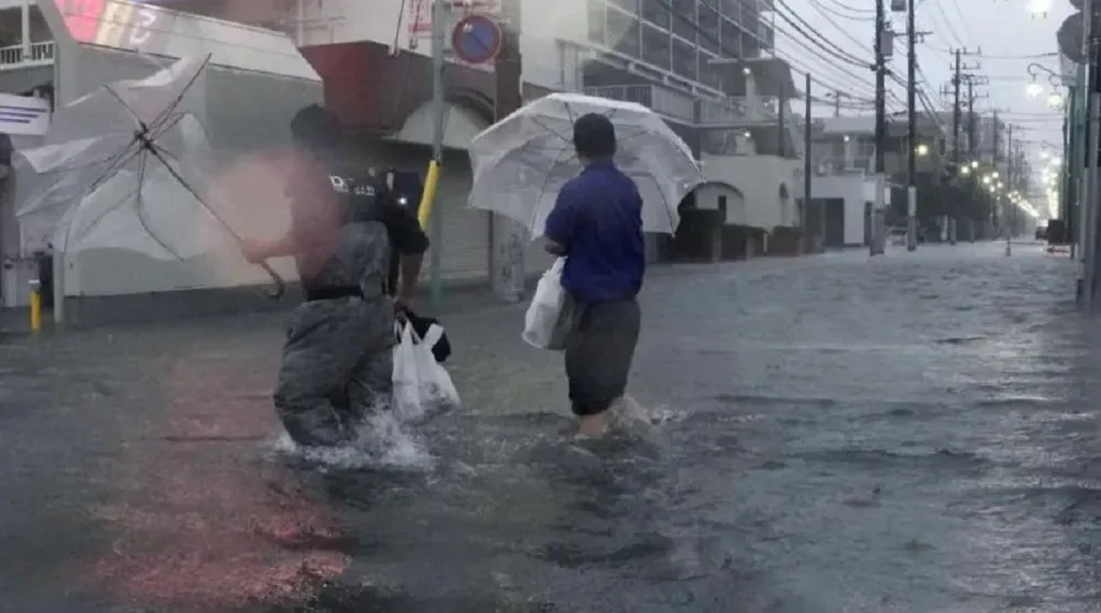
A powerful and destructive typhoon named Dujuan is currently charting a direct course toward the eastern coastline of Japan, prompting emergency authorities to initiate one of the most significant mass evacuation efforts in the region’s recent history. As of Monday, September 21, 2026, the storm system has intensified, bringing sustained winds of 144 kilometers per hour and threatening to unleash catastrophic rainfall across the Kanto region, including the densely populated Tokyo metropolitan area. With nearly 2 million residents advised to seek higher ground or reinforced shelter, the nation remains on high alert as meteorological experts warn of a "record-breaking" weather event.
Meteorological Profile and Current Status
The Japan Meteorological Agency (JMA) has classified Dujuan as a formidable tropical cyclone. The storm’s trajectory has been closely monitored since it began its northern shift over the weekend, gathering strength as it draws energy from the warm waters of the Pacific. By Monday morning, the central pressure of the system had dropped significantly, a primary indicator of its strengthening status.
The JMA has issued urgent warnings for the Izu Islands and Chiba Prefecture, which have already recorded unprecedented levels of precipitation over the past 48 hours. The agency’s data suggests that the cumulative rainfall between Sunday and Tuesday is projected to exceed the average monthly totals for the entire month of September. This localized, high-intensity rainfall is a hallmark of the current atmospheric instability surrounding the typhoon, which meteorologists fear could lead to widespread flash flooding and systemic infrastructure failures.
The Threat of Linear Rainbands
One of the primary concerns highlighted by climate experts is the potential for the formation of "linear rainbands." These atmospheric phenomena occur when a series of cumulonimbus clouds align in a narrow, elongated formation, continuously dumping extreme amounts of water over a confined geographical area for several hours.
In the context of the Kanto plain, which houses the world’s largest urban agglomeration, the impact of a linear rainband could be devastating. Unlike a standard storm front that passes quickly, a stationary or slow-moving linear rainband can overwhelm municipal drainage systems, leading to rapid urban flooding. Given the topography of the areas surrounding Tokyo, the combination of intense rainfall and saturated soil significantly elevates the risk of sudden, destructive landslides in rural and semi-urban hilly regions.
Emergency Chronology and Evacuation Protocols
The mobilization of government resources began in earnest on Saturday, September 19, as predictive models confirmed the likelihood of landfall. By Sunday, municipal authorities in the most vulnerable zones, particularly those in low-lying coastal areas and near river basins, issued "Level 4" evacuation orders.
- September 19: JMA upgrades the storm status; local governments begin preliminary checks of emergency shelters.
- September 20: Evacuation orders are expanded to include nearly 2 million residents across several prefectures, including Chiba and Kanagawa. Public transportation services begin announcing preemptive closures.
- September 21 (Current Day): Landfall expected within 24 hours. Major airline carriers, including Japan Airlines (JAL) and All Nippon Airways (ANA), confirm the cancellation of over 400 domestic and international flights to and from Haneda and Narita airports.
The evacuation process is complex, complicated by the ongoing necessity for social distancing and health protocols, which have become standard in disaster management since the post-pandemic era. Emergency shelters are operating with restricted capacities, forcing local governments to secure additional space in hotels and public facilities to ensure the safety of the displaced population.
Transportation and Infrastructure Disruptions
The logistical impact of Typhoon Dujuan is already being felt across Japan’s highly efficient infrastructure network. Beyond the mass cancellation of flights, the East Japan Railway Company has signaled that it will implement rolling service suspensions on major Shinkansen (bullet train) lines and local suburban routes starting Monday evening.
"Safety is our absolute priority," a spokesperson for the Ministry of Land, Infrastructure, Transport and Tourism stated in a press briefing. "We are urging the public to avoid non-essential travel and to remain indoors once the outer bands of the typhoon reach the coast. The structural integrity of power lines and public transit systems cannot be guaranteed under such extreme wind conditions."
In the capital, businesses have been advised to allow employees to work remotely, and many retail establishments and manufacturing plants have opted to close their doors for the duration of the storm. The disruption to supply chains, while temporary, highlights the vulnerability of the Kanto region to severe weather events that have become increasingly common due to changing global climate patterns.
Official Responses and Mitigation Efforts
The Japanese government has activated its emergency task force, coordinating between the Self-Defense Forces, the police, and fire departments to ensure a rapid response capability. Prime Minister Fumio Kishida issued a directive during an emergency Cabinet meeting, calling for "maximum vigilance" and urging local officials to prioritize the elderly and those with limited mobility during the evacuation process.
"The government will spare no effort to protect the lives and livelihoods of our citizens," the Prime Minister stated. "We are closely coordinating with meteorological experts to provide real-time information to the public. We ask that everyone monitors local news sources and follows the instructions of their local municipalities without delay."
The JMA has been criticized in the past for underestimating the speed at which storms can intensify. Consequently, for Dujuan, the agency has adopted a more cautious approach, erring on the side of early, broad-reaching warnings. This strategy aims to prevent the "last-minute panic" scenarios that have historically hindered evacuation efficiency.
Broader Implications: A Climate-Changed Reality
Typhoon Dujuan is not an isolated incident but rather a manifestation of a broader, more concerning trend. Data from the Intergovernmental Panel on Climate Change (IPCC) and local meteorological bodies consistently show that tropical cyclones in the Northwest Pacific are becoming more intense, with a higher proportion reaching "super typhoon" status.
The increased sea surface temperatures act as a catalyst, providing more energy for these storms. When these systems collide with the rugged, mountainous geography of Japan, the results are increasingly catastrophic. This cycle of extreme weather creates a persistent burden on the national budget, requiring billions of dollars in infrastructure reinforcement, such as the construction of massive underground flood-diversion channels, sea walls, and landslide-prevention barriers.
Furthermore, the economic impact of such events is substantial. Beyond the immediate costs of damage repair, the interruption of global shipping routes—many of which rely on the ports of Yokohama and Tokyo—can have a cascading effect on international markets. As Japan continues to invest in "resilient infrastructure," the reliance on early warning technology remains the most critical defensive layer in the nation’s arsenal.
Preparedness and Public Safety Recommendations
As the storm approaches, authorities continue to disseminate safety guidelines. Residents are advised to:
- Prepare Emergency Kits: Ensure that essential supplies, including water, non-perishable food, flashlights, and medical supplies, are packed and accessible.
- Secure Property: Close and lock all windows and shutters, and remove outdoor furniture or items that could become projectiles in high winds.
- Monitor Official Channels: Follow the JMA’s official website and local government social media feeds for live updates on evacuation orders and shelter locations.
- Stay Informed on Flooding: Utilize real-time river level monitoring services provided by the Ministry of Land, Infrastructure, Transport and Tourism.
As the sun sets on Tokyo, the city remains unnervingly quiet. The anticipation of Dujuan’s arrival has prompted a city-wide standstill, a testament to the respect—and fear—that the Japanese public holds for the power of nature. With 2 million people potentially displaced and the storm’s trajectory still capable of minor shifts, the next 24 to 48 hours will be a critical test of Japan’s disaster resilience and emergency management capabilities. The world watches as the nation prepares for what is hoped to be the final, but most challenging, storm of the season.