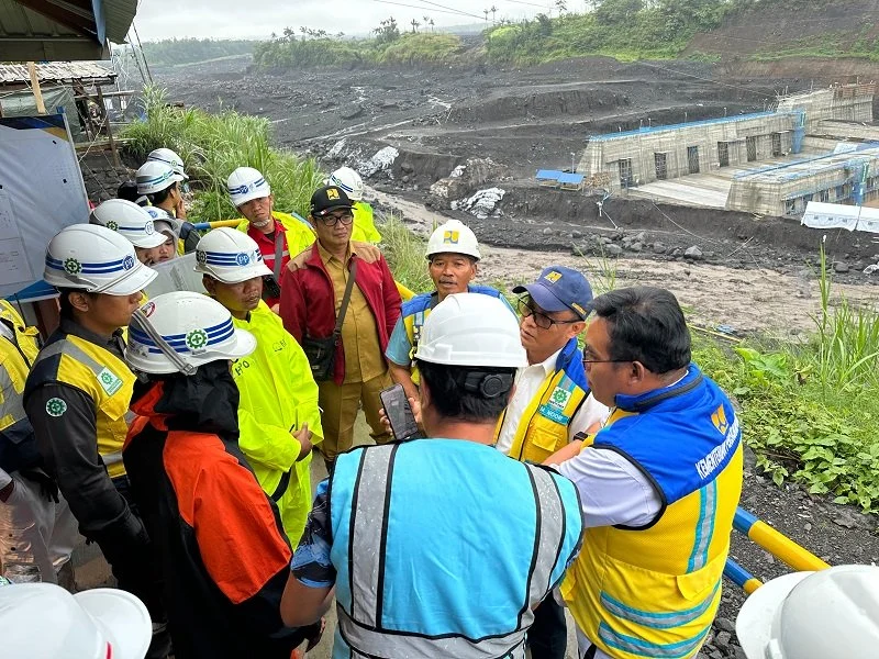
The Indonesian Ministry of Public Works (PU) has officially mobilized its emergency task force to address the severe impact of volcanic cold lava floods (lahar dingin) that struck the Lumajang Regency in East Java. Following a period of intense rainfall that triggered the overflow of volcanic material from the slopes of Mount Semeru, the ministry’s Balai Besar Wilayah Sungai (BBWS) Brantas—the regional office responsible for water resources—has launched a comprehensive damage assessment and mitigation operation. The intervention aims to restore critical infrastructure, protect residential areas, and ensure the safety of communities living along the riverbanks frequently affected by the volcano’s activity.
Chronology of the Volcanic Incident
The crisis unfolded in the early hours of Monday, November 2, 2026. According to meteorological and geological reports, heavy rainfall began to intensify over the peak and slopes of Mount Semeru shortly after midnight. Between 00:14 WIB and 05:32 WIB, the persistent downpour saturated the volcanic deposits accumulated on the mountain’s upper reaches.
The BBWS Brantas data indicates that the rainfall intensity was exceptionally high, recording 134.6 millimeters within a window of just over six hours. This extreme hydrological event mobilized significant volumes of loose volcanic debris, resulting in a lahar flow that surged down the river channels. The debris flow, characterized by volcanic material with particle sizes ranging from 25 to 65 millimeters, overwhelmed natural drainage systems and impacted man-made flood control structures designed to contain such occurrences.
Damage Assessment and Infrastructure Impact
The initial inspection conducted by the Ministry of Public Works task force reveals that several critical infrastructure assets have been compromised. The floods have caused varying degrees of structural damage, complicating the region’s flood defense capabilities. Among the reported damages are:
- Flood Control Infrastructure: Key concrete levees, specifically those designated under the Volcanic Debris Resource Recovery and Sedimentation Loading (VDRRSL) S4 KD 3 project, have been significantly buried or impacted by the influx of volcanic sediment.
- Sabo Dams: Three major sabo dams—structures specifically engineered to slow down and trap volcanic debris—have been affected. These dams are vital for preventing catastrophic mudflows from reaching downstream villages.
- Bridge Foundations: Scouring, a process where high-velocity water erodes the material around bridge foundations, has been detected at several points, particularly beneath suspension bridges that provide essential connectivity for rural residents.
These findings necessitate immediate intervention to prevent further deterioration, especially as the current rainy season is expected to bring continued precipitation to the East Java region.

Official Response and Strategic Commitment
Minister of Public Works Dody Hanggodo has underscored the gravity of the situation, emphasizing that the ministry is operating on a high-alert status. In a formal statement released on Tuesday, November 3, 2026, Minister Dody reaffirmed the government’s commitment to providing rapid relief.
"The Ministry of Public Works is fully committed to mitigating the impacts of this disaster by deploying all available resources, including heavy machinery and technical personnel," stated Minister Dody. "Our primary focus remains the safety and recovery of the affected residents. We are working in coordination with local authorities to ensure that infrastructure repairs are prioritized based on the most urgent risks to public safety."
The mobilization of heavy machinery, such as excavators and dump trucks, is currently underway to clear river channels of volcanic sediment. This dredging process is critical to restoring the flow capacity of the rivers, thereby reducing the likelihood of overflow in the event of subsequent rainfall.
The Geological Context of Mount Semeru
Mount Semeru, the highest volcano on the island of Java, remains one of Indonesia’s most active. Its geographical position and the tropical climate of East Java create a high-risk environment for lahars. The volcano frequently produces pyroclastic deposits—layers of ash, sand, and rock—that accumulate on its slopes. When heavy rains occur, these loose materials are mobilized into dense, slurry-like flows that can travel dozens of kilometers, carrying enough kinetic energy to destroy buildings, bridges, and agricultural land.
The frequency of these events in recent years has forced the Indonesian government to adopt a "living with the mountain" strategy, which involves the constant maintenance of sabo dams and early warning systems. However, as demonstrated by the November 2 incident, the sheer volume of material can sometimes exceed the design capacity of these structures, requiring constant monitoring and iterative engineering solutions.
Socio-Economic Implications for Lumajang
The impact of these floods extends beyond physical infrastructure. Lumajang is an area heavily reliant on agriculture and local trade. When lahars obstruct rivers or damage bridges, the economic lifeblood of the community is disrupted. Farmers often lose access to their fields, and the destruction of transport routes hampers the distribution of local goods.

Furthermore, the continuous threat of lahars creates psychological pressure on the local population. The Ministry of Public Works’ intervention is not merely a civil engineering task; it is a vital component of the regional social stability plan. By stabilizing the riverbanks and ensuring the structural integrity of bridges, the ministry aims to restore a sense of security to the residents, allowing for the resumption of daily economic activities.
Analysis of Mitigation Strategy
The current response strategy by the Ministry of Public Works can be divided into three phases:
- Emergency Phase: Immediate clearance of debris from critical waterways and stabilization of damaged levees to prevent secondary flooding.
- Assessment Phase: Conducting a thorough geological and structural survey to determine if existing sabo dams require retrofitting or if new sedimentation basins need to be constructed.
- Long-term Resilience: Integrating climate data into infrastructure design to account for the increasing frequency of extreme weather events, which are exacerbated by climate change and altered rainfall patterns.
Experts in water resource management suggest that while structural defenses like sabo dams are essential, they must be complemented by effective sediment management. Regular dredging and maintenance of the riverbed are just as important as the construction of dams. The Ministry’s move to conduct a comprehensive inventory of impacts is a positive step toward transitioning from reactive measures to proactive disaster risk management.
Future Outlook and Preparedness
As the rainy season in Indonesia reaches its peak, the Ministry of Public Works has placed all regional offices in high-risk volcanic areas on standby. The lessons learned from the current incident in Lumajang will be used to refine the standard operating procedures for future volcanic disasters.
The government is also coordinating with the National Disaster Management Agency (BNPB) and local disaster mitigation units (BPBD) to ensure that the evacuation routes and early warning sirens remain functional. While the physical damage to infrastructure is significant, the priority remains the prevention of casualties through the swift removal of volcanic material and the reinforcement of vulnerable river sections.
The resilience of the communities surrounding Mount Semeru depends largely on the speed and efficacy of these infrastructure interventions. As the Ministry of Public Works continues its cleanup and repair operations throughout the week, the public is advised to remain vigilant, adhere to government safety warnings, and stay updated through official channels regarding weather forecasts and volcanic activity reports. The dedication of the task force in the field, working under difficult conditions, represents the frontline of Indonesia’s ongoing efforts to mitigate the geological challenges posed by its volcanic landscape.