
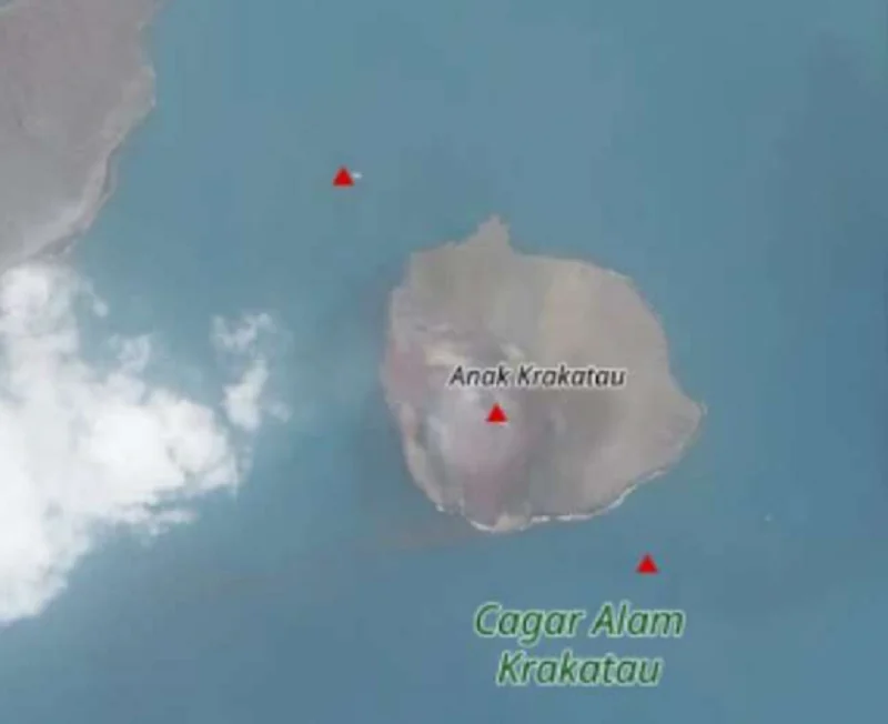
The geological landscape of the Sunda Strait has undergone a significant transformation following the emergence of two new landmasses in the vicinity of the Anak Krakatau volcano. Reported on Tuesday, September 22, 2026, these new islands have surfaced in the northwest and southeast sectors of the volcanic complex, sparking intense scientific scrutiny and heightened vigilance among maritime authorities. The discovery, which was initially brought to light through eyewitness accounts from local mariners and volunteer observers, has since been corroborated by satellite imagery, confirming that the dynamic nature of the Sunda Strait remains deeply tethered to the volatile temperament of its most famous submarine volcano.
Lana Saria, the Head of the Geological Agency of Indonesia, formally addressed the phenomenon on Thursday, September 24, 2026, confirming that the emergence of these islands is intrinsically linked to the sustained eruptive cycle that has gripped Anak Krakatau for the past several months. According to the official assessment, the northwest landmass is located approximately 760 meters from the coastline of the primary volcanic edifice, while the southeastern island sits closer, at a distance of roughly 495 meters.
Geomorphological Analysis and Structural Alignment
The positioning of these islands is not merely coincidental but follows a specific structural trend that has captured the attention of volcanologists. "When drawing a straight line, both islands form a clear orientation trending northwest-southeast, with the current crater of Anak Krakatau positioned directly between them," explained Lana Saria.
This specific alignment is suggestive of underlying tectonic and magmatic fissures that govern the growth of the Anak Krakatau complex. The Geological Agency is currently analyzing whether these new islands represent the formation of secondary eruptive vents or are the result of significant debris accumulation from the intense Strombolian activity observed throughout the summer of 2026. Satellite data from the Sentinel mission has been instrumental in providing a top-down perspective, confirming the physical expansion of the volcanic island’s footprint. However, the agency maintains a cautious stance, emphasizing that further field data—including bathymetric surveys and geological sampling—is essential to determine whether these landmasses possess a stable volcanic base or are transient features that may be reclaimed by the sea.
Chronology of the 2026 Eruptive Cycle
To understand the sudden appearance of these islands, one must look back at the recent history of the volcano. After a period of relative dormancy following the major events of 2018 and subsequent low-level activity that persisted through the end of 2023, the volcano entered a new, more aggressive phase in the middle of 2026.
- July 2, 2026: Anak Krakatau signaled a return to heightened activity, prompting the Geological Agency to elevate the alert status to Level III (Siaga). This transition marked the beginning of a sustained period of Strombolian eruptions.
- July – August 2026: The volcano maintained a steady output of incandescent rock, volcanic ash, and sulfurous gases. The frequency of these eruptions led to the continuous deposition of volcanic material into the surrounding waters of the Sunda Strait.
- September 3, 2026: The intensity of the Strombolian explosions reached a notable peak, contributing to a significant buildup of pyroclastic material around the flanks of the mountain.
- September 22, 2026: Mariners and observers reported the first clear sightings of the two new islands, confirming that the previous weeks of sustained eruption had physically altered the local topography.
Historical Context: The Legacy of Krakatau
Anak Krakatau, which translates to "Child of Krakatau," is the offspring of the legendary 1883 eruption that effectively decimated the original Krakatau volcano and altered global climates for years. Its modern iteration has been characterized by rapid, frequent growth cycles. The catastrophic events of December 2018, which triggered a localized tsunami in the Sunda Strait due to the partial collapse of the volcano’s southern flank, remain a sobering reminder of the hazards posed by this region.
Because of this history, the Geological Agency of Indonesia treats every shift in the morphology of Anak Krakatau with the utmost seriousness. The mountain is monitored 24/7 via the PGA (Gunungapi) posts located in Kalianda, Lampung, and Pasauran, Banten. These posts provide real-time data on seismic activity, deformation, and thermal signatures, serving as the primary defense in the early warning system for coastal communities in the surrounding provinces.
Implications for Maritime Safety and Coastal Communities
The emergence of new land in a major international shipping lane such as the Sunda Strait carries significant logistical and safety implications. The Sunda Strait serves as a vital maritime artery connecting the Java Sea to the Indian Ocean, facilitating the transit of commercial vessels, tankers, and local passenger ferries.
The Ministry of Transportation and the Indonesian Navy are expected to issue updated maritime notices (NOTAMs and Notices to Mariners) to ensure that vessels maintain a safe distance from the volcanic complex. The risk of secondary underwater landslides, which could potentially trigger further tsunamis, remains the primary concern for the Geological Agency.
"We are urging all mariners, fishing vessels, and tourism operators to strictly adhere to the exclusion zone," stated an official spokesperson. "The structural integrity of the area surrounding these new islands is currently unverified. The potential for underwater landslides, regardless of the eruption’s intensity, is a factor we cannot overlook given the history of this volcano."
Scientific Outlook and Future Monitoring
The scientific community is currently mobilizing to deploy more granular monitoring equipment, including automated buoys and perhaps drone-based surveys to map the exact composition of the new islands. The key question for researchers is whether these islands are composed of loose, unconsolidated pyroclastic material—which would make them highly susceptible to wave erosion—or if they represent a more permanent, lava-fed growth of the volcanic base.
If the islands are indeed the result of continuous magma ascent, it suggests that the plumbing system beneath Anak Krakatau is undergoing a major recharge, potentially indicating that the Level III (Siaga) status will remain in effect for the foreseeable future. Researchers from academic institutions across Indonesia are collaborating with the Geological Agency to integrate satellite-based deformation monitoring with ground-based seismic data to create a comprehensive model of the current volcanic evolution.
Conclusion
The appearance of these two islands is a stark reminder of the geological fluidity of the Indonesian archipelago. While the formation of new land is a natural outcome of volcanic processes, the location of Anak Krakatau within a densely populated and economically critical region necessitates a high degree of caution and constant scientific surveillance. As the world watches, the Geological Agency continues its work, balancing the objective of gathering critical data on the volcano’s evolution with the urgent necessity of protecting the lives and livelihoods of those residing along the coasts of Banten and Lampung. For now, the "Child of Krakatau" continues its relentless growth, forcing humanity to once again adapt to the raw, unceasing power of the earth’s crust in motion.