
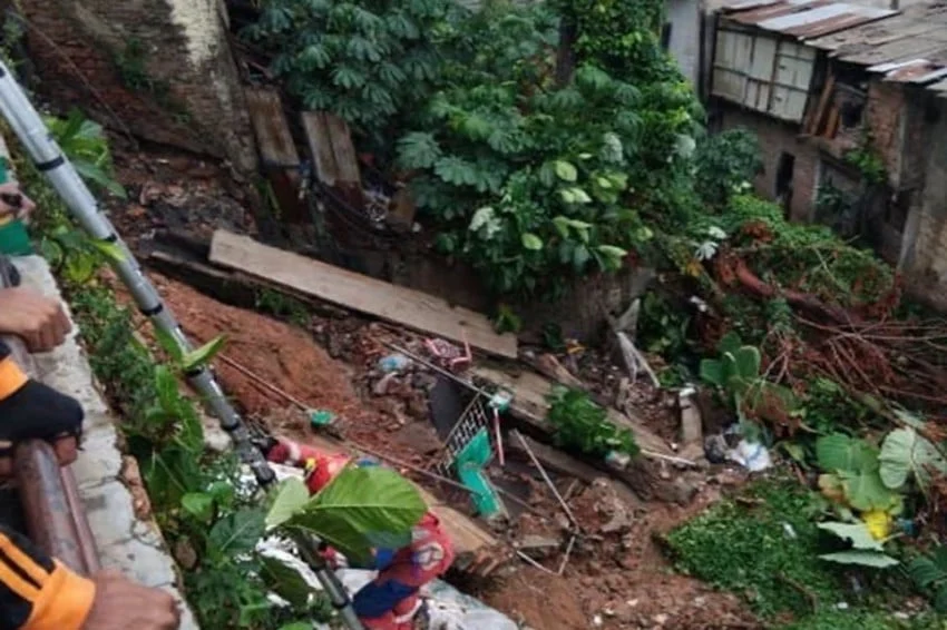
Jakarta experienced yet another severe reminder of its vulnerability to extreme weather and geological shifts when a destructive landslide struck a densely populated residential area in South Jakarta. The incident, which was triggered by a combination of torrential downpours and underlying soil displacement, occurred on Jalan Kemang Selatan X, located within the administrative jurisdiction of Bangka Village in the Mampang Prapatan sub-district. The catastrophe highlights the escalating risks faced by urban communities situated near water bodies and unstable terrain during the peak of Indonesia’s rainy season.
The disaster severely compromised the structural integrity of multiple properties, leaving local authorities scrambling to secure the area, mitigate further damage, and provide emergency relief to the affected residents. While initial rapid assessments confirmed that the calamity caused substantial material losses and structural failures, emergency management teams have verified that swift coordination averted any potential loss of life or severe physical injuries among the local populace.
Main Facts of the Incident
The catastrophic event unfolded during the early afternoon, catching residents off guard as relentless rain pounded the capital city and its surrounding regions. According to official reports released by the Jakarta Regional Disaster Management Agency (BPBD DKI Jakarta), the landslide was officially logged at approximately 14:10 Western Indonesia Time (WIB). The primary trigger was identified as heavy, continuous rainfall that saturated the topsoil, exacerbating existing geological vulnerabilities and leading to a sudden shift in land structure.
The geographical scope of the damage concentrated heavily along the riverbank and retaining walls adjacent to local properties on Jalan Kemang Selatan X. Five permanent residential structures suffered direct structural compromises, ranging from cracked foundations and collapsed exterior walls to severe undermining of the land upon which they were built. Additionally, a commercial padel court facility situated adjacent to the residential zone sustained severe property damage, with its boundary walls and foundational earth collapsing into the lower basin.
Despite the chaotic nature of the disaster, localized emergency response protocols were activated almost immediately. Neighbors assisted one another in evacuating the danger zone before official first responders arrived. The incident directly impacted eight family heads (KK), whose homes were declared unsafe for habitation due to the continuous risk of secondary landslides. These families were swiftly relocated to temporary shelters established by local community leaders in coordination with municipal sub-district officials.
Chronology and Sequence of Events
Understanding the precise sequence of events leading up to the landslide is crucial for emergency planners and disaster mitigation experts. The morning of the incident began under heavy overcast skies, typical of Jakarta’s monsoon season. By late morning, meteorological monitors recorded an escalation in precipitation levels, leading to a sustained, high-intensity downpour that overwhelmed local drainage networks and heavily saturated the clay-rich soils characteristic of South Jakarta’s low-lying areas.
At approximately 13:45 WIB, residents in the immediate vicinity of Jalan Kemang Selatan X began noticing unusual environmental precursors. Several homeowners reported hearing low-frequency rumbling sounds emanating from beneath the ground, accompanied by distinct physical tremors and vibrations. These warning signs, often indicative of subsurface soil liquefaction and displacement, prompted immediate concern among residents living closest to the embankment.
By 14:05 WIB, the tension reached a critical threshold as the foundational earth supporting the upper residential tier began to sheer away. Witnesses described a rapid and terrifying sequence where concrete retaining walls buckled under the immense weight of saturated mud and debris. Within minutes, a massive section of earth slid downward, dragging boundary walls, fences, and parts of residential structures along with it.
At 14:10 WIB, the slope experienced a major structural collapse. Emergency calls flooded the Jakarta disaster hotline, prompting BPBD DKI Jakarta to dispatch rapid assessment teams, search and rescue personnel, and heavy equipment to secure the perimeter. By 15:30 WIB, municipal engineers had cordoned off the affected zone to prevent civilian access, while social welfare units began registering displaced families for emergency logistical support, including food supplies, clean water, and temporary bedding.
Supporting Data and Urban Vulnerability Context
The disaster on Jalan Kemang Selatan X does not exist in a vacuum; it is part of a broader pattern of environmental and infrastructural challenges facing Indonesia’s sprawling capital. Jakarta’s topography, characterized by low elevation, dense river networks, and extensive urban development, makes it exceptionally prone to hydro-meteorological hazards.
Geological surveys indicate that large portions of South Jakarta, particularly areas adjacent to major water tributaries such as the Krukut and Mampang rivers, rest on alluvial soil deposits. These soils possess high water retention capabilities during heavy rains but lose structural cohesion rapidly when oversaturated. When combined with rapid urbanization—which has seen permeable green spaces replaced by concrete and asphalt— rainwater runoff accelerates, increasing the hydraulic pressure on riverbanks and retaining walls.
Data from the National Board for Disaster Management (BNPB) reveals that hydrometeorological disasters, including floods, flash floods, and landslides, account for more than 80% of all recorded natural disasters in Indonesia annually. Within Jakarta, localized land subsidence driven by excessive groundwater extraction and structural overloading further compounds the risks associated with heavy rainfall events.
Furthermore, residential density in commercial and semi-residential zones like Kemang often leads to high architectural loads close to natural slopes. Property owners frequently construct retaining walls or modify natural drainage paths to maximize land use, sometimes inadvertently destabilizing the slopes over long periods. When extreme weather events occur—such as the intense downpours recorded during this wet season—the cumulative stress on these modified landscapes frequently culminates in sudden structural failures.
Official Responses and Agency Statements
In the immediate aftermath of the disaster, municipal and provincial authorities moved quickly to establish command structures at the site. Marulitua Sijabat, the Head of Operations for BPBD DKI Jakarta, provided comprehensive updates regarding the nature of the damage and the ongoing disaster relief operations.
"The objects impacted include boundary walls and land belonging to the local padel facility, as well as five distinct residential properties owned by local citizens," Sijabat stated during a press briefing following the incident. He elaborated on the mechanics of the disaster, noting that continuous heavy rainfall acted as the primary catalyst for the underground shifts that preceded the collapse.
Sijabat emphasized that the initial reports compiled by field officers highlighted the rapid onset of the disaster. "The landslide occurred after heavy rain fell on the location, during which residents heard rumbling sounds and felt ground vibrations. This was followed by the catastrophic collapse of the soil and retaining walls in the area," he explained.
Significantly, the BPBD confirmed that proactive evacuation measures and the fortunate timing of the collapse prevented any fatalities or severe injuries. "We can confirm that there were zero casualties resulting from this event," Sijabat affirmed. Regarding the displaced residents, local authorities ensured that all affected households received immediate attention, though formal assessments regarding total material losses remain ongoing. "The financial valuation of the property damage is currently undergoing further calculation by respective municipal agencies," he added.
In tandem with the BPBD, local administrative units—including the sub-district (Kelurahan) and district (Kecamatan) offices—mobilized public health workers and social services to monitor the well-being of the evacuees. Temporary medical posts were set up to address any stress-related conditions or minor ailments among the displaced population, particularly vulnerable demographic groups such as the elderly and young children.
Broader Impact and Implications for Urban Resilience
The Kemang Selatan landslide serves as a stark warning regarding the pressing need for enhanced urban planning, stricter zoning enforcement, and proactive environmental mitigation strategies in Jakarta. As climate change continues to intensify weather patterns—manifesting in shorter, more erratic, yet significantly more intense downpours—cities across Southeast Asia must adapt their infrastructure to withstand escalating environmental pressures.
The incident carries several critical implications for urban management and public safety:
Infrastructure Auditing and Riverbank Regulations
Municipal authorities are under increasing pressure to conduct comprehensive structural audits of all retaining walls and riverbank fortifications, particularly in high-density commercial and residential zones. Many existing structures were built decades ago under less stringent engineering codes and may lack the drainage capacity required to handle modern rainfall volumes. Strengthening oversight on river setback regulations (garis sempadan sungai) will be vital to preventing future construction too close to vulnerable slopes.
Early Warning Systems in Urban Settings
While meteorological agencies provide broad regional forecasts, localized geological hazards like landslides and ground subsidence often occur with very little warning. Developing hyper-local early warning mechanisms—such as soil moisture sensors, inclinometers on high-risk slopes, and community-based monitoring networks—can significantly reduce response times and save lives during extreme weather events.
Climate Adaptation and Drainage Master Plans
The ongoing revitalization of Jakarta’s drainage systems, retention basins, and pump stations remains a critical priority. However, engineering solutions alone cannot resolve the crisis; nature-based solutions, such as restoring permeable surfaces, greening river corridors, and expanding water retention zones upstream, are essential for reducing peak runoff rates that trigger soil erosion.
Socio-Economic Support for Climate Displaced Populations
Disaster management frameworks must also evolve to address the plight of families displaced by localized climate hazards. While emergency relief provides immediate sustenance, long-term recovery often involves complex negotiations regarding land ownership, relocation assistance, and the rebuilding of structurally compromised homes. Ensuring equitable and transparent support mechanisms will prevent vulnerable communities from sliding into chronic poverty following environmental shocks.
Conclusion
The landslide on Jalan Kemang Selatan X is a multifaceted wake-up call for Jakarta’s civic leaders, urban planners, and residents alike. While the absence of casualties is a testament to the resilience and situational awareness of the local community—as well as the rapid response of municipal agencies—the physical and financial toll underscores the fragility of urban ecosystems under the weight of severe weather. As climate volatility persists, bridging the gap between reactive disaster response and proactive structural resilience will remain the defining challenge for the Indonesian capital’s sustainable future.